Students looking at a board in a classroom

About Flo

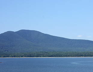
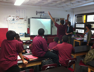
Flo: The Watershed Project is an artistic, scientific and educational game simulation designed to inspire real world awareness about the importance of clean water, the causes of climate change, the impact of flooding, and the need for sustainable practices in the New York City Watershed both at the source and the areas of consumption. Flo offers a rare opportunity to create a unique bridge between the digital and natural worlds. Here one experiences what it may be like to "be" water.  Not only an artwork, the project has educational components in the form of mini-games that address water pollution, sustainability, and ecofriendly practices. Flo seeks to foster stewardship and conservation in ensuring the health and sustainability of New York City and the upstate source areas and towns. Flo is targeted for Middle School students in the West-of-Hudson Watershed and in New York City, but the online version of the game and information will be available to other schools, communities and environmental groups.

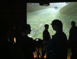
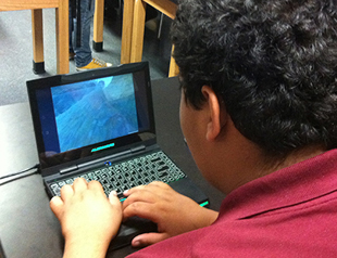
By communicating with young people in their "native digital" language, the project offers a rare opportunity to create a unique bridge between the digital and natural worlds. The game is played from first person water point of view using the Kinect motion sensing input device to impart the empathetic, visceral feeling of being first person water. (Downloadable versions of the game come in an on-line version that uses simple mouse and keyboard commands or if you have the Kinect interface you can download the Kinect version of the game.)

Aerial photo of open water with wave ripples

Life as Water

Flo’s life as water is traced from “birth” in the rain over the mountains as one falls to earth like a raindrop. Then one moves through the saturated soil into high gradient streams, stream riffles, past native riparian buffers, ducking through and around streambeds, branching throughout the system of cascading creeks, rivers, tributaries and then into reservoirs, through tunnels and aqueducts, and onwards to become drinking water in New York City.

Photo of hills in the distance behind a body of water

Levels and Mini-Games

These waterway scenarios, based on watershed geographical data, will be the various “levels” of the game. One must avoid or correct the dangers that Flo has on the journey through a series of mini-games that enable the Flo journey to continue. These include:

Game screenshot of two people standing by a tree

Sediment Control and Forestry

Reducing sediment and turbidity: addressing erosion and associated water quality impacts by stream management/rehab projects and the use of various techniques including riparian plantings and encouraging and educating people to avoid building in flood plains.

Encouraging positive forestry practice with sound selective forest management plans determining when and how much timber should be cut at a time, and developing deer management plans to protect forest understory and regrowth.

Game screenshot of a car in a driveway in front of a carport, with an image of a rain garden

Development Impacts

Altering conditions of development impacts: correcting adverse conditions from asphalt road oils, salt and septic waste through wiser town planning, good septic practices, proper storage of salt, bio swales to help filter asphalt road oils from parking lots and roadways and reducing impervious cover by designing to traffic density, minimizing roadway length & widths, reducing sidewalk widths, cul de sacs, and the footprint of parking areas, sharing driveways and creating hydrologically functional lots. Managing impact by the following: conservation of natural areas, creating vegetated buffers, filter strip and riparian reforestation, vegetated open channel, tree planting, rooftop flow disconnection, stream daylighting, rain gardens, green roofs, storm water planters, rain tank/cisterns, and using permeable paving.

Game screenshot from above an area with intersecting rivers mapping flooding

Flood Control

Implementing storm water control systems: for new construction or retrofit projects to avoid the impacts by preserving natural features such as protecting undisturbed areas, buffers, reduction of clearing and grading, locating sites in less sensitive areas, and soil restoration.

Game screenshot of three cows standing in a field

Farm Pollutants

Reducing farm pollutants, such as chemical fertilizers and livestock waste, prevented by moving cows away from streams and into areas where fresh water troughs are available for them to drink from. Farm pollutants may also be reduced by utilizing natural organic fertilizers instead of chemical fertilizers. And finally, the pollutants can be counteracted through encouraging organic farming, by eliminating antibiotics and chemicals in animals' food, feeding livestock healthy, natural diets that have no animal remains, and using waste for fertilizer with proper methods of composting with care to temperature, and composting for several years before selling.

Game screenshot of an open area in a forest

My Stream

Once the player has completed the game proper, he or she will be able to input real world data from observations of a nearby stream such as channel condition, water level, turbidity, canopy cover, quality of riparian vegetation, substrate size, aesthetics, and macro invertebrates. This information will be used to determine the health level of the “My Stream” flow level, which the player will then be able to navigate as they would any other flow in the game. This unique feature of The Watershed Project again links the player to the real world and the real world to the experience of the game flow.

Photo of trees with hills in the background

Sustainability

Sustainable and ecofriendly practices are incorporated throughout the game and include:

  • Alternate and newer forms of energy such as wind, solar, hydro, geothermal heating/cooling, other
  • Transportation alternatives such as electric, hybrid cars, bikes, walking, public transportation, and emerging new ideas such as nitrogen cars
  • New forms of clustered housing and villages
  • Better agricultural practices and food production
Photo of roadway next to a body of water

Bridge Between the Digital and Natural Worlds

To foster Flo’s health and safety on her journey, the player must ensure, through their choices that healthy environmental conditions exist. To complete the highest quest in the game, one must go out into the field and upload “real world” data in the form of water testing results (both observational and chemical) in addition to artistic observations and impressions.

Photo of students in a dark room standing in front of a projector showing gameplay

A Unique Alliance of Students

A unique alliance of university students from Rensselaer Polytechnic Institute designed, created, and programmed the project with input from middle school students from the upstate watershed source area and from New York City. The project seeks to not only educate scientifically, but it also aims to activate empathy about the importance of fresh, clean water and the need for all to work together to protect this valuable resource to ensure the health and sustainability of New York City and the upstate source areas and towns. We are partnering with a number of scientists and environmental groups, The Catskill Center for Conservation & Development, and The Ashokan Center where, if additional funding permits, we will all meet for a two day media event with field work in the form of scientific stream health observations and water testing, artistic impressions and expressions, the premier of Flo: The Watershed Game and Fieldwork Project, and sharing our experiences about the role of water in our lives.

Photo of student playing the game on a laptop

Web Portal

This web portal has information about The Watershed Game and Fieldwork Project, including the downloadable version of the game, information about water testing (chemical and observational), climate change, maps of the WOH watershed area, links to other relevant websites, and an upload area for the database of water quality testing results, field observations, and artistic reflections and actions. The website is designed to be inspirational for further study of water conservation and stewardship as it is a living, growing portal with database support. The project is available to schools, community, and environmental groups who wish to understand and contribute to solutions to the complex issues being brought on by climate change.

Photo of a hill with open water in front

Significance

The NYC water supply system provides approximately one billion gallons of water each day to more than eight million residents of NYC, to the millions of tourists and commuters who visit throughout the year, as well as about 120 million gallons a day to one million people living in Westchester, Putnam, Ulster, and Orange counties. 90% of the water comes from the six reservoirs in the five-county Catskill Mountain/Delaware River Region of New York State. The West of Hudson (WHO) Watershed is home to 72,000 full- and part-time residents who live in small towns among forested mountains and river valleys. It is imperative to the sustainability of both New York City and the upstate source areas and towns that the communities work together.

This project is made possible with funds from the Catskill Watershed Corporation in partnership with the New York City Department of Environmental Protection.